
The Carta Hydrographica y Chorographica de las Yslas Filipinas, commonly known as the 1734 Murillo Velarde Map, is often cited as the “Mother of all Philippine Maps.” Looking specifically at the segment depicting the island of Cebu (labeled “Zebu”), one is immediately struck by how recognizable the geography and toponymy are to the modern observer, despite the passage of nearly three centuries. The map serves not only as a navigational tool but as a historical register of the settlements that formed the backbone of the province presented in this Old Map of Cebu.
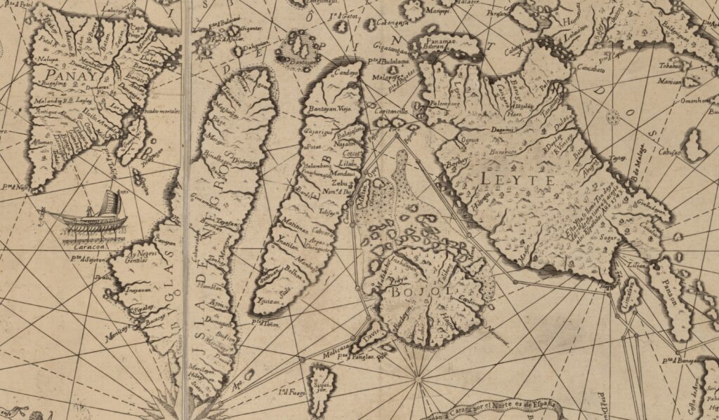
At the heart of the island’s representation is the label “Zebu” accompanied by a distinct church icon and the text “Nom. d Ihs”. This abbreviation stands for Villa del Santísimo Nombre de Jesús (Village of the Most Holy Name of Jesus), the name given to the settlement by Miguel López de Legazpi. This highlights the city’s primacy as the cradle of Christianity in the archipelago. Just north of the city, we see “Mandaui,” unmistakably the modern industrial hub of Mandaue City. To the south lies “Cauit,” referring to Kawit Island or Point (now largely reclaimed and integrated into the South Road Properties and Cebu City coastline). Further south is “Talisay,” which remains a major component of Metro Cebu today. Across the channel, the island of “Mactan” is clearly defined, featuring the settlement of “Opon.” For centuries, the town of Opon was the center of life on the island until it was renamed Lapu-Lapu City in 1961. The map also identifies “Olango”, known today as the Olango Island Group, a critical sanctuary for migratory birds.
Moving northward, the map identifies “Liloan” and “Cotcot,” names that persist unchanged; Cotcot is still a prominent river and barangay between Liloan and Compostela. The northern tip of the island presents a fascinating historical snapshot with the labels “Candaya” and “Bantayan Viejo.” Candaya is an ancient name often associated with the northern territories of Cebu. “Bantayan Viejo” translates to “Old Bantayan,” which correlates directly to the modern municipality of Daanbantayan (Daan meaning old in Cebuano). This distinguishes it from the island of “Bantayan” located just off the coast, which served as a lookout (or bantayan) against Moro raiders.
The eastern coast, historically the more populated side due to trade winds and arable land, shows a string of settlements that are major municipalities today. We see “Argao,” a town that still boasts one of the most significant colonial churches in the province. South of it lies “Daraguete,” a clear phonetic ancestor of today’s Dalaguete, the “Vegetable Basket of Cebu.” Further down is “Bolhon,” or the modern heritage town of Boljoon.Near the southern tip, the map marks “Sialo.” While there is no modern town named Sialo, this refers to the Vicarage of Sialo (or Siaro), a large ecclesiastical district that once encompassed the Carcar and Sibonga areas, though the map places it further south near Santander. The map also marks “Sanbuan,” which is the modern town of Samboan, known for its Jacob’s Ladder and waterfalls.
The western coast, though less detailed, features prominent settlements that remain key towns. “Barili” is clearly marked, historically a crucial crossroads crossing the island. “Balambang” corresponds to Balamban, now the shipbuilding capital of the Philippines. Further south, “Ynatilan” is the archaic spelling for Ginatilan, and “Matitinao” refers to the Matutinao River area in Badian, famous today for the Kawasan Falls.
Below is a table which presents the names of the places of Cebu as seen in 1734 as opposed to today.
| Name in the 1734 Murillo Velarde Map | Name Today |
| Zebu / Nom.ª d Ihs | Cebu City |
| Mandaui | Mandaue City |
| Talisay | Talisay City (Unchanged) |
| Cabcar | Carcar City |
| Mactan | Mactan (Unchanged) |
| Opon | Opon (Unchanged) |
| UNKNOWNCEBU | UNKNOWNCEBU |
| Cauit | Kawit |
| Liloan | Liloan (Unchanged) |
| Cotcot | Cotcot (Unchanged) |
| Bantayan Viejo | Daanbantayan |
| Candaya | Daanbantayan/Maya(?) |
| Pinaghumajan | Pinamungajan |
| Balambang | Balamban |
| Barili | Barili (Unchanged) |
| Argao | Argao (Unchanged) |
| Daraguete | Dalaguete |
| UNKNOWNCEBU | UNKNOWNCEBU |
| Bolhon | Boljoon |
| Ynatilan | Ginatilan |
| Matitinao | Matutinao |
| Sanbuan | Samboan |
| Najalin | Danao(?) |
| Potat | Putat (A barangay in Tuburan) |
| Mambage | Alcoy |
| Yguizan | Nueva Caceres (A barangay in Oslob) |
In examining the 1734 Murillo Velarde map, we see that the skeleton of modern Cebu was already fully formed by the 18th century. The Spanish orthography—using ‘Y’ for ‘G’ or ‘I’, and ‘Z’ for ‘C’—barely masks the identity of these towns. It is a testament to the enduring nature of these communities that almost every name scribed by the engraver Nicolas de la Cruz Bagay can still be found on a Google Map today.

