
The history of Oslob is often overlooked by those who are not invested in it, most tourists have become accustomed to seeing whale sharks as the main attraction in Oslob, located about 100 kilometers south of Cebu City. Other attractions include its pristine waters, numerous resorts, and the Oslob plaza and heritage church, which features a baluarte (Otherwise known in Cebuano as “Bantayan Sa Hari” which are watchtowers built during the Spanish colonial period) that has been partly cut in half by the action of the sea waves crashing against it over centuries. The structure still retains its vintage wooden planks, which feel smooth and soft to the touch—almost like a pillow. Another notable site is the Cuartel, which is commonly known for being the unfinished remains of a military garrison by locals and tourists alike which was left incomplete in 1898 because of the Philippine revolution. However, the true nature of the Cuartel has been in contention with one local historian raising that it is more likely a Casa Tribunal or a courthouse. Daanlungsod, Oslob is a barangay of Oslob and holds within it an unknown treasure.

Daanlungsod, Oslob
Beyond the fold of the usual itinerary of transient tourists and visitors alike is a lesser-known, yet grander and older structure than those in the plaza of Oslob. It lies just 1–2 kilometers south of the main plaza, in what was once the original site of town of Oslob when it was first established. The Poblacion (Town center) of Oslob was not where it is situated at the present time. Over 250 years ago, Oslob was once located in a site now fittingly known as “Daanlungsod” meaning “Old Town” in Cebuano.|UnknownCebu| This historic site of Baranagay Daanlunsod, contains within it, a historic treasure that has yet to be fully recognized – The so called “Estaca” as called by the locals and as indicated by a sign on the highway. According to the Cebuano TV History show, “Kabilin,” hosted by Dr. Jobers Reynes Bersales, Estaca means “military detachment,” and is probably older than the walled fortifications surrounding the Churches of Dalaguete and Argao. The primary purpose of this fortress was to defend the townspeople and the infant settlement of Oslob from marauding moro-pirates who stalked the seas from Mindanao to Palawan, threatening communities with death and plunder. Below, I will go into the physical description of the “Estaca” along with details on individual elements such as the watchtowers, the ruins, and other elements.
A Physical Guide to the “Estaca” of Oslob
Basic Physical Description of the Fort: As a whole, the “Estaca” of Oslob, is located on a gently sloping plain which rises from the sea. It is bounded on the east by the Natalio Bacalso National Highway, and bounded on all sides by initially low-lying vegetated terrain which gradually rises at a gradual incline. The fortification of Daanlungsod stands as the largest single enclosed fortress in the entirety of the province of Cebu. The fort is a rough approximation of a quadrilateral fortress based on shape alone with the side facing north being slightly longer to account for the existence of a large boulder on the north-eastern corner of the fort. The topography of the fort rises gradually from the sea, resulting in an estimated 15-20 meter difference in height from the Natalio Baclaso highway to the highest point of the fortification.|UnknownCebu| The mamposteria (coral rubble stuck together with lime mortar to build structures or in generics: the Spanish term for masonry) walls adapt gradually to the shape of the earth, changing slightly in height to conform with the existing topographical profile of the terrain. Watchtowers are present in each corner of the fortification except for the north eastern corner where a massive limestone boulder appears to have served as a natural bastion. Coral stone portals supported by original wooden lintels are extant on the northern, eastern, and southern sides of the fort. The portals come in twos on each side and are situated equidistant from each other. The foundation of several buildings are present on the northern, southern, and eastern portals. A modern chapel stands at the front of the Fortress.

Dimensions of the Fortification: Through measurements on Google Earth with the help of satellite imagery and physical observations in situ by the author, we have come to an estimate as to the total size of the fort. The western side of the fort (northern side from the road) measured more or less about 140 meters in length. The Southern side (western side from the road) measured more or less about 155 meters in height. The total estimated area enclosed by the walls of the fortress comes to around 22,000 sqm give or take a few hundred square meters for the interiors of the corner watchtowers. Whereas the well-known “Fort San Pedro” in Cebu City only measures a total of 2,025 Square meters in area, this fortification easily dwarfs it by 10 times or more.|UnknownCebu| Another apt comparison is in the neighboring town of Boljoon, where a similar, although smaller, fortification exists. According to the TV Show, Kabilin, the fortification surrounding Boljoon church measure 120 meters by 80 meters, coming in with a total area of 9,600 square meters. Based on measurements taken in the past, the fort of Daanlungsod, Oslob, is more than 2.2 times larger than the fort surrounding the church of Boljoon. It must be noted however that these figures are a rough estimate, however, what remains clear is that this fort is much larger than any other in Cebu by a long shot and remains unchallenged in this regard.
Below: Figure 1. is a cartographic illustration of the “Estaca” with measurements. Figure 1.2 is a cartographic illustration of the “Estaca” with Labels. Compass on the upper left is rotated to signify true north at the top.


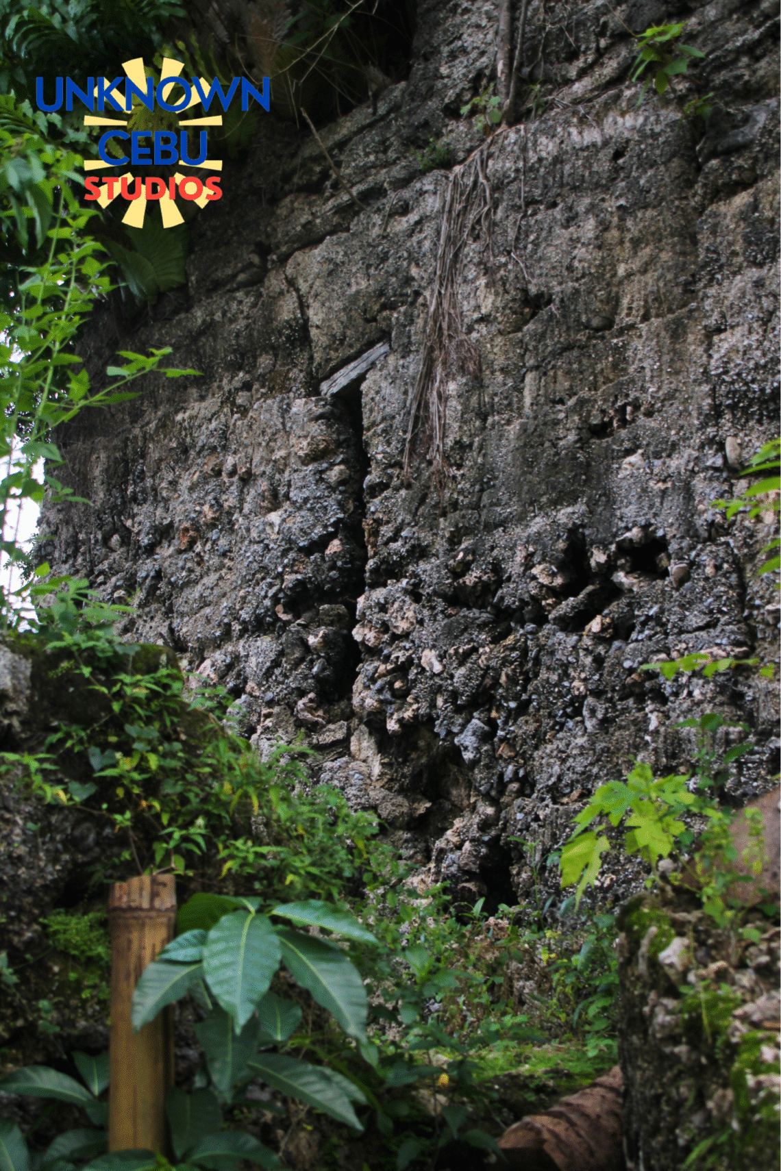
The Walls: The perimeter walls of the “Estaca” extend around the entirety of the area, though a short 10 meter section on the north-western corner appears to have a deliberately demolished area to make a right of way to a private property on that side. The walls appear to be made of “mamposteria” which, as stated previously, is a material made of coral stone piled to height and then put together with lime mortar acting as a cement. The coral stones are laid in horizontal semi-irregular courses that appear to have been secured by wooden planks at the time of curing – leading to a theory where construction could have been done in stages. The surface is plastered with lime that has eroded over time revealing the underlying individual stones.|UnknownCebu| Based on nearby shorelines which feature an abundance of boulders and smaller rocks, the coral stone appears to have been sourced locally. The walls are 2.5 meters in height with some sections reaching as much as 3.0 meters tall ( as observed on the south-western corner). The walls are between 1-2 meters thick. No buttresses are present. Currently, the walls are under threat of further erosion caused by the growth of plants. Another threat is human intervention as with the case of the demolished portion on the north-western side, and development in the form of houses being built on all sides. In comparison with other similar structures, the walls fall in line with established styles known in the province.


The Portals: There are 6 portals in total. Two portals are located on each side of the fort on the southern, northern, and eastern sides. The western side does not have any portals; this explains why a portion was demolished for access. The portals are still made of mamposteria and do not have a guard house or adjoining structure. They are arched and form a noticeable arch in comparison with the regular height of the perimeter wall. Front portal 1 and Southern Portal 2 still retain their original wooden lintels while the rest have lost them.


The Watchtowers: These watchtowers called “Baluarte” (meaning Bulwark or Bastion in english) or “Bantayan sa Hari” by the local population meaning “Watch of the King”, are present all around Cebu. These watchtowers were built all around Cebu, most famously under the guidance by the warrior-priest Fray Julian Horabuena Bermejo (1777-1851). The primary purpose of these watchtowers were to defend against Moro pirate invaders and act as telegraph stations for communications between provinces. Oslob has the highest number of watchtowers at a grand total of 13. There are 5 watchtowers that comprise the fort complex as a whole. These 5 watchtowers can be further subdivided: There are 4 corner watchtowers that are connected to each other by the perimeter walls and one free-standing watchtower near the center of the complex. |UnknownCebu|
Table on Watchtower Descriptions (Photos are labeled below table)
| Corner Octagonal Watchtower (SE Side) | Octagonal in Shape. 7-8 Meters high and made of mamposteria on bottom half and faced with cut coral stone blocks on top half. Structure is sturdy and well built. Each side is crenellated with crenellations at 2-3 meters high. Wooden lintels missing. Circular holes present on inside. Notable is the presence of a seal dating the fortress to “1789” at interior entrance. Cracks are present at the base and coral stone blocks have been looted. |
| Corner Quadrilateral Watchtower (NE Side) | Quadrilateral in shape. 6-7 Meters high. Made of mamposteria faced with lime mortar. Structure is sturdy and well built. Each side is crenellated on the corner with crenellations at 2-3 meters high. Wooden lintels present on window slits on each side of the tower. Wooden posts and post holes present on walls, indicating foundation for higher wooden floor. A coconut tree grows in the center. |
| Central Quadrilateral Watchtower (Eastern Side) | Quadrilateral in shape. 7-8 meters in height and made of mamposteria faced with lime mortar. Structure is well built, but deteriorating. Edges of the tower are slightly rounded. Each side is crenellated with 1 meter tall crenellations. Wooden lintels are present on all window slits of which there are 1 on each face. Wooden posts and post holes are present on walls. Massive breach reportedly created by 2013 earthquake on northern side of tower. T-shaped openings with wooden lintel on the inside on all sides below window slits. |
| Corner Quadrilateral Watchtower (SW side) | Quadrilateral in shape. 6-7 meters high. Made of mamposteria faced with lime mortar. Structure is sturdy, but deteriorating. Edges of tower are well defined. Each side is crenellated with 1 meter tall crenellations. No wooden lintels. No window slits. Cracks on top half caused by vegetation. |
| Interior Octagonal Watchtower | Octagonal in shape. 7-8 meters high. made of mamposteria faced with lime mortar. Structure has been halved on eastern side with rubble scattered throughout immediate area. Post holes present, but no wooden lintels. Strange streak present on western face (possible trace of wood formwork for proper curing of stone during construction.) |


The “Ruins”: Present on several sides of the enclosed portion of the fortress are several rectangular ruins. The rectangular ruin closest to “Northern Portal 1” only has low walls remaining at a meter in height. Large chunks of coral stone rubble, some of which are one or two meters across, are present in the immediate area. Post holes are present on the ground and a disturbed area of earth is present on the inside of the rectangular ruin. Another ruin next to “Northern Portal 2” is more defined. The walls of this ruin stand at a meter or two in height. This ruin appears to have an extended portion of coral stone wall on the inside which could act as “seats” to an Escuela Catolica or some similar structure (This is similar to the ruins of an Escuela Catolica in the Poblacion where seats made of coral stone are done in an amphitheater style. Strangely, this ruin has several shards of ceramic scattered on the ground in the inside, though this is most likely a modern occurrence of dumping. The rectangular ruins at Front Portal 1 and Southern Portal 2 are the least defined meaning their forms have deteriorated over time to the point that they cannot be very well recognized. They are characterized by coral rubble being strewn about and low walls not even reaching a meter in height. |UnknownCebu| In the past, during the author’s first visit in 2019 to this site, a local reported seeing iron balls of a large size inside the ruin closest to Front portal 1. They described it as “Mga bug-at ug bakal nga bola, murag mga granada ug dagway.” translated literally as, “…Heavy and iron balls, that look like grenades.” These could possibly have been cannon balls or other implements of war which were being stocked at the structure before being abandoned. An interesting item of note is that, according to Dr. Jose Tio Bonpua, a historian from Oslob, an old church with a stone altar once existed within the fort grounds: could one of these stone ruins be the old stone altar?


A Historical Perspective
The Daanlungsod fortification, locally known as the Estaca sa Daanlungsod, stands today as one of the most enigmatic and least-documented Spanish-era defensive structures in southern Cebu. Its existence points to a broader colonial military system that once guarded the Visayan coastline against seaborne Moro raiders from the south between the 17th and 19th centuries. Based on local accounts and physical evidence, the fort’s origins can be traced to around 1789, during the late Spanish colonial period when coastal settlements like Oslob, Boljoon, and Argao faced repeated incursions that devastated communities and disrupted trade.
The fort’s location at Daanlungsod—literally “old town”—reveals that it once served as the original poblacion or settlement core of Oslob before the present-day town center was relocated farther inland. This move likely occurred in the early 19th century, after a major attack or series of raids rendered the coastal site unsafe. The Estaca’s imposing walls, constructed using mampostería (rubblework of coral stone and lime mortar), enclose what appears to have been a fortified plaza with quarters, a chapel, and an octagonal watchtower. These features are consistent with the Spanish military design principles introduced by Fray Julián Bermejo of Boljoon, the Augustinian friar-commander who organized a chain of coastal fortifications throughout southeastern Cebu. The Daanlungsod fort thus formed part of a defensive network that included the church-fort complex of Boljoon to the north and smaller watchtowers in Santander and Samboan to the south, functioning as both a military outpost and a civilian refuge during attacks.

Fray Julian Bermejo’s Statue at the Plaza of Oslob’s Immaculate Conception Church. Behind this statue is another Baluarte.
While no formal archival record has yet been found detailing its construction, its strategic positioning, craftsmanship, and similarities with other Bermejo-era structures support the idea of coordinated defense planning. |UnknownCebu| The octagonal watchtower at the corner of the fort, built atop a limestone boulder that rises naturally from the shore, is a unique adaptation of Spanish coastal architecture to local terrain. From this vantage, lookouts could survey the Cebu Strait for approaching vessels, lighting signal fires to warn neighboring towns.

There are signs that the fort is either being threatened or up for restoration. Recently, many trees have been cut on the outside and inside of the fort grounds. Is this an indicator for a potential restoration?
In the aftermath of the Moro raids and the relocation of Oslob’s poblacion, Daanlungsod was gradually abandoned. Over the centuries, vegetation overtook its coral walls, sections collapsed, and quarrying activities damaged parts of its perimeter. Despite this neglect, the Estaca remains a powerful vestige of Cebu’s maritime defense heritage—a silent testament to the community’s resilience during a volatile chapter of Philippine history.
Today, the site faces environmental and preservation challenges. Coastal erosion threatens the lower foundations, while unmanaged plant growth continues to weaken the structure’s masonry. The local heritage organization TALAPAMANA (Talaan sa mga Pamanang Kabilin) has recognized the site’s historical significance and advocates for its inclusion in the municipal inventory of cultural properties under the National Cultural Heritage Act (RA 10066). TALAPAMANA has called for community awareness programs, vegetation clearing, and heritage mapping to prevent further degradation. Their ongoing documentation efforts aim to protect the Estaca as both a cultural landmark and an educational site, ensuring that future generations understand its role in shaping Oslob’s early history and identity.
A Traveler’s Perspective
Traveling from Cebu City to Daanlungsod, Oslob is fairly straightforward and offers several convenient options depending on your budget and preferences. The most common and budget-friendly way is by bus from the Cebu South Bus Terminal located along N. Bacalso Avenue. At the terminal, look for Ceres Liner buses with signboards that read “Bato via Oslob” or “Samboan via Oslob.” Make sure to confirm with the conductor that the bus stops at Daanlungsod before boarding. The journey typically takes around three to four hours, depending on traffic and the number of stops along the way, passing through towns such as Minglanilla, Carcar, Argao, Dalaguete, and Boljoon before reaching Oslob. The one-way fare ranges from around 200 to 300 pesos, depending on whether you choose an air-conditioned or non-air-conditioned bus.
For those who prefer convenience, private vehicles are another good option, allowing for flexible stops along scenic coastal routes. You can also book private tours or van transfers offered by various Cebu tour companies, which typically include door-to-door pickup and stops at major attractions in southern Cebu. Whichever option you choose, the drive to Daanlungsod offers a beautiful view of the Cebu coastline and makes for a comfortable and scenic trip southward.

Bibliography
Bersales, Jobers R. “Oslob Controversies, ca. 1882.” Cebu Daily News, February 1, 2017. https://cebudailynews.inquirer.net/121303/oslob-controversies-ca-1882.
———. “The Baluartes of Cebu.” Cebu Daily News, May 10, 2017. https://cebudailynews.inquirer.net/132498/the-baluartes-of-cebu.
Bersales, Jose Eleazar R., and Ino Manolo. Integracion / Internacion: The Urbanization of Cebu in Archival Records of the Spanish Colonial Period: An Exhibition at the University of San Carlos Museum, November 13, 2013 to May 12, 2014. Cebu & Manila: University of San Carlos Press and National Archives of the Philippines, 2017.
Blanco Andrés, Roberto. “El ‘Padre Capitán’ Julián Bermejo y la defensa contra la piratería mora en Cebú.” Archivo Agustiniano 101, no. 219 (2017): 7–54. https://doi.org/10.53111/aa.v101i219.1224.
Capigas, Stan. “Cebu’s Lonely Sentinels of the Sea.” LANGYAW Travel | Food | Culture, September 21, 2009. https://langyaw.com/2009/09/21/cebus-lonely-sentinels-of-the-sea/#comments.
Gerschwiler, Paul. Bolhoon: A Cultural Sketch. Cebu City: The Foundry, 2009.
———. The Pueblo of Bolhoon. Cebu City: Ramon Aboitiz Foundation, 2016.
National Commission for Culture and the Arts. “TALAPAMANA Visayas.” Talapamana ng Pilipinas (Philippine Registry of Heritage). Accessed October 28, 2025. https://talapamana.ncca.gov.ph/index.php/component/content/article/talapamana-visayas?catid=10&Itemid=101
Ta

